Sand, Shadow & Silence: A Photographer's Guide to Mesquite Flat Sand Dunes
here is a moment just after sunrise in the Mesquite Flat Sand Dunes when the light is so low and so golden that the ridgelines of the dunes cast shadows as deep and dark as ink. The sand glows amber, the air smells faintly of mineral dust, and the Panamint Mountains loom in every direction. For a brief window — maybe ninety minutes at most — the entire scene becomes a living abstract painting, redrawn each day by the wind. This is the Death Valley I came to photograph, and these are the images I brought home.
I spent four days in Death Valley National Park in May, based out of Stovepipe Wells Village Hotel, just minutes from the dunes. This post is a photographer's honest account of the experience: the light, the logistics, the heat, the hidden corners of the dune field that most visitors never reach — and the practical tips that will help you get better images than I did on my first morning.
DEATH VALLEY: THE STAGE
QUICK FACTS
Size: ~3.4 million acres (5,270 sq mi) — largest national park in the contiguous U.S.
Elevation: −282 ft at Badwater Basin (lowest point in North America)
Record heat: 134°F (56.7°C) at Furnace Creek, July 10, 1913 — the highest reliably recorded air temperature on Earth
Annual rainfall: Less than 2 inches on average
Nearest major airport: Harry Reid International, Las Vegas (~2.5 hr drive)
Cell service: Largely unavailable inside the park
Death Valley National Park sprawls across approximately 3.4 million acres — making it the largest national park in the contiguous United States, larger than the state of Connecticut. The valley floor sits at up to 282 feet below sea level at Badwater Basin, flanked by mountain ranges that trap radiated heat and block moisture. On July 10, 1913, a temperature of 134°F (56.7°C) was recorded at Furnace Creek — the highest reliably documented air temperature ever measured on Earth.
The park straddles the California–Nevada border and takes in an astonishing diversity of geology: salt flats, volcanic craters, rainbow-colored badlands, canyon narrows, and, of course, the iconic sand dunes. Despite its forbidding reputation, Death Valley supports over 1,000 plant species, including the park's namesake mesquite trees, and is home to the endangered Devils Hole pupfish, one of the rarest fish in the world. The park was established as a national monument in 1933 and redesignated a national park in 1994.
I visited in May, which is considered shoulder season — past the mild spring crowds but before the brutal peak of summer. Daytime temperatures on the valley floor reached the low 90s°F during my trip. That sounds manageable until you are trudging through deep sand at midday with no shade in sight. Nights cooled considerably, making early mornings bearable and perfect for photography. If you can visit between November and March, conditions are far more forgiving. That said, the quality of May's golden-hour light is extraordinary.
GETTING THERE & AROUND
The most practical gateway to Death Valley is Harry Reid International Airport in Las Vegas, Nevada. From the airport it is roughly a 2.5-hour drive west on US-95 and then CA-190 into the park. I recommend downloading Google Maps offline before you leave Las Vegas — cell service disappears almost entirely once you enter the valley, and you will want navigation on hand, especially for side roads and remote locations. The park is vast, and distances between photo locations are far greater than they appear on a map.
Speaking of distances: driving to the far corners of the park is a serious time commitment. The remote Racetrack Playa — famous for the mysterious "sailing stones" that leave tracks across its dry lakebed — requires over two hours of driving each way from Stovepipe Wells, much of it on rough, unpaved road that demands a high-clearance 4WD vehicle. I was unable to make that journey with my rental car. If the Racetrack is on your list, plan accordingly and check road conditions with the park in advance.
Amenities inside Death Valley are genuinely scarce. There are only a handful of gas stations in the entire park, and fuel prices are significantly higher than outside. Fill up before you enter and again whenever you get the opportunity. There is a gas station directly across the street from Stovepipe Wells Village Hotel, which made refueling convenient during my stay.
WHERE TO STAY: STOVEPIPE WELLS VILLAGE HOTEL
I stayed at Stovepipe Wells Village Hotel, one of only a few lodging options inside the park. Its location is ideal for photographers targeting the Mesquite Flat Sand Dunes — the dunes are less than a five-minute drive from the hotel's front door. Waking up before sunrise and walking out to shoot without a long drive is a genuine luxury in a park this size.
I will be honest about the conditions: my room's air conditioning was not functioning properly during my May visit. With daytime temperatures in the low 90s°F, this made midday hours in the room uncomfortable. Fortunately, the nights cooled off significantly, which kept sleeping manageable. If you are planning a summer trip in particular, I would strongly recommend confirming the AC situation in advance and having a backup plan.
One unexpected highlight: the hotel restaurant serves a remarkably good vegan meatball sub — not the kind of thing you expect to find in the middle of the Mojave Desert. It became my go-to recovery meal after early morning shoots. The restaurant's hours are limited, so check ahead and plan your meals around the schedule.
MESQUITE FLAT SAND DUNES: THE LANDSCAPE
The Mesquite Flat Sand Dunes are the most accessible dune system in Death Valley, sitting at an elevation of approximately 1,000 feet and covering roughly 14 square miles at the north end of the valley near Stovepipe Wells. The main parking area sits directly off California State Route 190, and the dunes begin just steps away. They are named for the honey mesquite (Prosopis glandulosa) shrubs that dot the sand — one of the few plants tough enough to thrive here, anchoring small mounds with root systems that can reach water 30 to 50 feet underground.
The dunes were built over thousands of years by windblown quartz sand eroded from the surrounding alluvial fans and creek beds. They are classified as a star dune system at their highest points, meaning the primary dune crests radiate outward in multiple directions as a result of shifting wind patterns. The tallest dune in the field rises roughly 100 feet above the valley floor. What appears from the parking lot to be a gentle slope is, once you begin climbing through deep, soft sand, a surprisingly strenuous ascent.
The landscape is not static. Wind continuously reshapes the crests and slip faces, erases footprints, exposes new ripple patterns, and occasionally uncovers unusual geological features buried beneath the sand — like the ancient dried mudflat visible in one of the photographs below. Every visit is genuinely different.
"Every visit is genuinely different. The wind redraws the dunes between one sunrise and the next, erasing footprints and revealing entirely new compositions."

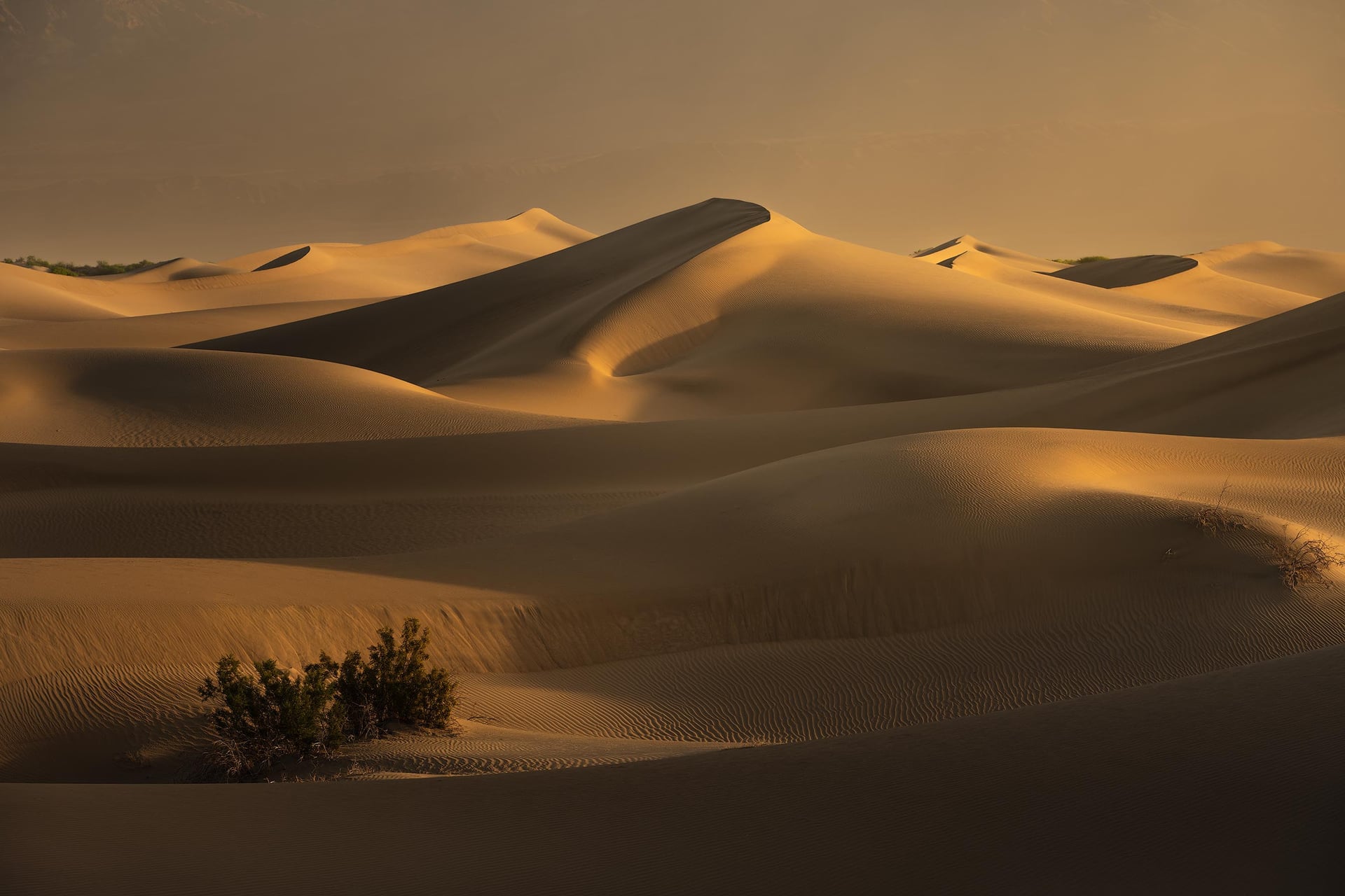
The low angle of early-morning light rakes across the dunes, carving every ridge and hollow into sharp relief. A cluster of mesquite shrubs anchors the left foreground while the Panamint Range dissolves into a warm amber haze of airborne sand in the distance. This sweeping, atmospheric view captures what draws photographers here from around the world: the feeling that the desert stretches on forever, as ancient and indifferent as time itself. I shot this from the eastern section of the dune field, an area far less trafficked than the main approach — notice the absence of footprints on the pristine dune faces.
PHOTOGRAPHING THE DUNES: WHAT I LEARNED
TIMING IS EVERYTHING
The single most important decision you will make as a photographer at Mesquite Flat is when to be there. I shot exclusively during the hour before sunrise through about two to three hours after. The low-angle light during this window creates the dramatic interplay of warm, lit ridgelines and deep, cool shadows that define the most compelling dune photographs. By late morning the sun has climbed high enough that shadows shrink, the sand washes out, and the heat begins its assault on your body and your spirit.
In May, I started to overheat if I stayed past about 9:30–10 a.m. I would pack up, return to the hotel, rest during the worst of the midday heat, and plan for the following morning. Sunset light is also beautiful, but the heat of a May afternoon makes getting into position uncomfortable at best and dangerous at worst. Know your limits.
GO EAST, NOT WEST
The vast majority of visitors hike west from the main parking lot toward the tallest, most visible dune. The result: that entire area is covered in footprints by mid-morning, which can ruin foreground compositions that depend on pristine, wind-rippled sand. I had far better luck moving to the eastern side of the dune field. You can also park on the shoulder of Route 190 east of the main lot, which shortens the walk into this section. The dunes here are equally dramatic, and the solitude is remarkable — especially at sunrise, when you may have entire ridgelines entirely to yourself.
KEEP EXPLORING
The dunes reward the curious. Do not plant yourself in front of the first striking scene you find and work only that spot. Walk over ridges, drop into bowls, climb to peaks, and look in every direction. I regularly discovered compositions — a curved shadow cutting across a perfect ripple field, a lone mesquite silhouetted against a lit dune face, a cracked mudflat island suddenly appearing between sand hills — that I never would have found without pushing further. If you find a great composition but the light is wrong, drop a pin in Google Maps and come back the next morning. I did this repeatedly and it paid off every time.
WIND IS YOUR FRIEND
When the wind picks up, magic happens. Airborne sand particles fill the atmosphere and wrap around the distant mountain ranges like a soft diffusion filter, stripping away hard detail and lending the entire scene a painterly, dreamlike quality. The dune crests themselves come alive with blowing sand streamers that add drama and a sense of motion. If you feel the wind rise while you are shooting, stay in the field as long as you safely can. Those conditions are not guaranteed.
MARK YOUR POSITION — YOU WON'T GET LOST, BUT YOU MIGHT GET CONFUSED
The dune field is large enough to feel disorienting once you are deep inside it. Landmarks disappear behind ridges. It is very unlikely you will become genuinely lost — you can almost always navigate by the mountains on the horizon — but I recommend downloading Google Maps offline (or a GPS-capable app like Gaia GPS) before you arrive, since there is no cell service in the park. Having your position tracked gives you peace of mind to explore freely.

Shooting into the face of the dunes rather than across them compresses the successive ridgelines into a series of sinuous, parallel curves. The raking sunrise light exaggerates every form: the lit crests glow amber while the valleys between them fall into near-total shadow, producing a graphic abstraction that owes as much to fine art printing as it does to landscape photography. Wind-blurred sand softens the Panamint Range into a warm, indistinct backdrop that prevents the eye from escaping the central drama. I find this image meditative — the repeated rhythm of light and dark has an almost musical quality.

Moving in close and eliminating sky, horizon, and vegetation entirely transforms the dunes into something purely sculptural. Here, three overlapping dune crests coil around one another in warm amber light, their smooth faces interrupted only by a faint field of micro-ripples caught in the lower center. The shadows between the crests are so deep they read almost as solid black, creating a graphic two-tone image that defies the sense of scale — you cannot immediately tell whether you are looking at something six inches tall or sixty feet tall. That ambiguity is exactly the point. This type of intimate, abstract composition only becomes available in the first hour of light, when the sun angle is low enough to create such extreme tonal contrast.

One of the most unexpected discoveries in my four days on the dunes: a large patch of ancient, cracked mud — a dried playa remnant — emerging from the sand as if surfacing from beneath the valley's memory. The pale grey, tessellated surface of this geological relic creates a jarring textural contrast against the warm, smooth sand surrounding it. A lone mesquite catches the morning light in the middle distance, and the rolling dune crests behind it lead the eye toward the Amargosa Range on the horizon. This is the kind of composition the dunes quietly hide from visitors who stay close to the parking lot. It required a long walk east and a willingness to drop over a ridgeline into an unfamiliar bowl. The light was only right for about twenty minutes. That is the deal the desert offers you.
BEYOND THE DUNES: OTHER MUST-SEE LOCATIONS
ZABRISKIE POINT
Zabriskie Point is one of the most photographed viewpoints in the American Southwest, and for good reason. The badlands below the overlook — formed from ancient lake sediments compressed into golden and ochre mudstones — glow with an almost unearthly warmth at sunrise. The layered, eroded formations radiate outward from the viewpoint like the folds of a collapsed accordion. It is a classic for a reason. Arrive before dawn if you want to stake out a position without fighting the crowd, and stay past sunrise for the gradual color shift as the light climbs.
BADWATER BASIN
At 282 feet below sea level, Badwater Basin is the lowest point in North America and one of the most otherworldly places I have ever stood. The vast salt flat — a remnant of an ancient lake called Lake Manly that once filled the entire valley — stretches for miles in every direction, its crystalline salt polygons crunching underfoot. I visited for sunset, and then stayed well into the night. A recent rainstorm had left a thin sheet of water standing in the basin, and what happened once the stars came out was one of the most striking astrophotography experiences of my life: the Milky Way and a field of stars reflected perfectly in the still water, the salt surface disappearing so that sky and reflection became one. Ethereal does not fully capture it.
RACETRACK PLAYA (A NOTE)
The Racetrack Playa, where large rocks — some weighing hundreds of pounds — leave long, mysterious tracks across the dry lakebed, is one of Death Valley's most legendary destinations. The phenomenon, now understood to be caused by thin sheets of ice forming under the rocks during winter rain events and then propelled by light winds, is genuinely remarkable to witness firsthand. However, reaching it requires more than two hours of driving each way from Stovepipe Wells, most of it on rough, rocky unpaved road that will damage a standard vehicle. I could not make the trip in my rental car. If you are planning to visit, rent or bring a vehicle with high clearance and check the latest road conditions with the park service before attempting it.
HEAT, HYDRATION & SAFETY
Essential Safety Tips for the Dunes:
Start early, finish early. Be on the dunes at or before sunrise and aim to wrap up by mid-morning, especially in spring and summer. Midday heat on the open sand can be dangerous.
Bring more water than you think you need. At least one liter per hour of active hiking in warm weather — more in higher temperatures. The dry desert air accelerates dehydration without you noticing.
Wear sun protection. A wide-brim hat, sunglasses, and sunscreen are non-negotiable. The sand reflects UV radiation upward as well as absorbing heat from above.
Download offline navigation before you arrive. There is no cell service in the park. Google Maps, Gaia GPS, or any satellite-capable mapping app with offline maps will allow you to navigate and track your location without a signal.
Tell someone your plan. Even on a short dune walk, let someone know where you are going and when you expect to return.
Fill up on fuel whenever you can. Gas stations inside the park are few and far between, and prices are high. Do not let your tank drop below half.
Respect the terrain. The dunes are physically demanding. The sand is deep, the climbs are steep, and the heat compounds fatigue faster than you expect. Know your fitness level and turn back before you are exhausted.
FINAL THOUGHTS
Death Valley is not an easy place to be. The heat, the remoteness, the absence of cell service and ordinary conveniences — all of it asks something of you that most destinations do not. But that is also precisely what makes it extraordinary. The landscape does not reveal its best angles to visitors who stay near the parking lot. It asks you to walk further than is comfortable, to get up before you are ready, to return the next morning and the morning after that.
I left with four images from the dunes that I genuinely love — images I could not have made anywhere else on Earth. I left wanting to go back. That, I think, is the measure of a place worth visiting.
If you have questions about shooting in Death Valley or want to know more about any of the locations above, feel free to reach out. And if you make it out to the Mesquite Flat Sand Dunes, explore the eastern side. You will not regret it.
TAGS
Death Valley National Park, Mesquite Flat Sand Dunes, Desert Photography, Landscape Photography California, Death Valley Photography Tips, Stovepipe Wells, Badwater Basin, Zabriskie Point, Sand Dune Photography, Astrophotography Death Valley